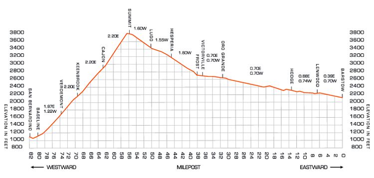
TRAINMASTER BY WERNER MEER  US-RAILROAD-SHOP KILCHBERG
HOCHWEIDSTRASSE 3  CH-8802 KILCHBERG (ZÜRICH) SWITZERLAND (founded 1977)
PHONE *41-44-715-3666, FAX *41-44-715-3660, E-MAIL trainmaster@bluewin.ch
Go back to our Website - click here

added / updated: July 20, 2019

Cajon Pass Maps
Accurate Map as of 2018
The copyright belongs to Steve Jessup & Todd Gillette as published in Railroads Illustrated 2018 Annual on page 81.
Used by permission of White River Productions, 24632 Anchor Ave. Bucklin, MO 64631
https://www.whiteriverproductions.com/


Below are some links about Cajon Pass Elevation BNSF Summit: 3777 feet (1151 m), I-15 Summit is 4190 feet (1280 m)
Cajon Pass Main Page - click here


Cajon Pass 2019 - click here


Cajon Pass 2018 - click here


Cajon Pass 2017 - click here


Cajon Pass 2016 - click here


Cajon Pass Hill 582 - click here


See large map - click here


Here is the link to the BNSF 3rd Main Track Project 2007 - 2008 (we are having 9 pages)  -  click here
We are having a great photo documentation of the 3MT Contruction by BNSF with more than 900 photos.


8 different and detailed Maps of Cajon Pass with captions (Mile Posts and Location) by Gary G. Gray - click here
New 8/11: Maps "How to find" Hill 582, Sullivan's Curve, Noisy Point by Gary G. Gray - click here


Accurate Map as of 2010
We are very thankful to Michael Amrine, who took the time to draw a special map with all tracks over Cajon Pass as it was accurate in 2010 (incl. BNSF 3rd Main Track). With permission by Michael Amrine.
© 2010 Michael Amrine - All Rights Reserved - graphicsmike@gmail.com

Did you see the fantastic Cajon Pass Photography by Michael Amrine on railpictures.net? - click here


MILEPOSTS (MP) between Barstow and San Bernradino over Cajon Pass

The original track through Cajon was completed in 1885 with a ruling grade of 3%. The MilePosts were numbered from East to West starting at Barstow.

In 1913, a two mile longer second main track was completed with a ruling grade of 2.2%. The NEW 1913 main became the NORTH (#1) track while the original track became the SOUTH (#2) track. Since there was a two mile difference in the tracks between West Summit Island and Cajon Jct, the new MilePosts for the North track were given an "X" to denote a separate track. When the #1 and #2 tracks returned to parallel running at Cajon Jct, the newer North #1 track simply "lost" two miles and became MilePost equal to the original track.

With completion of construction of the new Third Main track, the "MILES" on MilePosts on the #1 and #2 tracks were lengthened to about 1.15 miles each to coincide (at Cajon Jct) with the 1913 track Mile Posts. In other words, for railroad purposes the distance between Summit and Cajon is now considered to be the same for all three tracks, even though the actual distance is 1.15 miles between mile posts on tracks #1 and #2.


Barstow - Summit Summit - Cajon Station (2,2 %) Cajon Station - San Bernardino
MP Location MP Location MP Location
0.0 Barstow 55.9 Summit 62.8 Cajon Station
6.7 Lenwood 56.7X West Summit Island 63.4 Curved Bridge
13.6 Hodge 57.2X Silverwood - Bridge USFS 3N45 64.4 Swarthout Canyon Road X-ing
21.1 Helendale 58.2X Hill 582 65.0 Blue Cut
31.5 Oro Grande 58.9X former Tunnel 1 (Alray) 67.3 Old Keenbrook
34.6 East Victorville 59.2X former Tunnel 2 (Alray) 69.4 Keenbrook
36.7 Victorville 59.5X Bridge over Baldy Mesa Road 71.0 Devore
38.0 Frost 60.2X CP Walker 73.9 Verdemont
39.1 Flyover 60.6X Davis Ranch Road X-ing 75.0 Ono
41.1 Thorn 62.2X Pine Lodge - Mormon Rocks 79.9 Baseline
45.1 Hesperia 63.0X Sullivan's Curve 80.6 7th Street
50.1 Lugo 64.1X Bridge over Cajon Creek 81.4 San Bernardino
52.8 Martinez 62.8 Cajon Station - -
55.9 Summit - - - -


Cajon 1 with 2006 photos - click here Cajon 2 with 2007 photos - click here Cajon 3 with 2008 photos - click here
Cajon 4 with 2009 photos - click here Cajon 5 with 2010 photos - click here Cajon 6 with 2011 photos - click here
Cajon 7 with 2012 photos - click here Cajon 8 with 2013 photos - click here Cajon 9 with 2014 photos - click here
Cajon 10 with 2015 photos - click here Cajon 11 with 2016 photos - click here Cajon 12 with 2017 photos - click here
Cajon 13 with 2018 photos - click here Cajon 14 with 2019 photos - click here Cajon 15 with 2020 photos - click here
Cajon 16 with 2021 photos - click here Cajon 17 future Cajon 18 future
History of Hill 582 photos - click here Ranchero Road Project - click here Colton Flyover Project - click here
Highway 138 East Project - click here Mojave River Bridges - click here Green Tree Blvd. Project - click here

Go back to Cajon Pass Main Page - click here

Home Cajon Pass Photo Gallery HO Layout